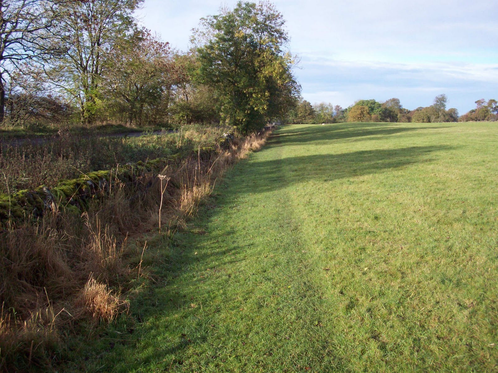
Portgate to Heavenfield is a three and a quarter mile stretch of part of the 84 mile Hadrian's Wall National Trail, in Northumberland. The route can be found in areas of permanent pasture and passes through Stanley Plantation and the Military Road Plantation. After the B6318 Military Road crossing, the trail runs parallel with the Wall ditch through pasture, until Heavenfield.
As a National Trail Volunteer Ranger, I am normally found walking on my section of the Trail. This is a three and a half mile stretch from Port gate (The Errington Arms, Stagshaw roundabout, near Corbridge) to Heavenfield (near Chollerford).
With such a good spell of weather, I decided to travel a little further west and visit some of the iconic sites in the Central Section of the World Heritage site. The first decision of the day was, where to start my walk from?
For the day walker, there are a number of good places to park the car and set off on the Trail. For example:
Walltown – near to the RomanArmyMuseum, a good place to park, picnic and join the Trail travelling east or west.
Walltown Quarry
Cawfields – car park situated beside the quarry, again a good place to picnic and explore the Trail travelling east or west.
Cawfields Quarry
Steel Rigg – car parkis located adjacent to the monument and offers outstanding views of the Wall.
Steel Rigg
I decided to park at Steel Rigg and walk east towards Housteads. With ‘wall to wall sunshine’ other people had obviously had the same idea. The overflow car park was in use, but I managed to get a space in the main parking area.
I readied myself for the walk ahead and made sure that I had my camera. Normally used to take photographs of any problem areas on my stretch of the Trail, today it was to get some views of such an important historical site.
If you are to follow the route of the Wall from Steel Rigg, walking boots or shoes are an essential piece of your equipment. Parts of the Trail follow the contours of the land and this means some climbs and descents on stone steps. One thing to remember is that you will be walking at a fairly slow pace, due to you following the contours of the land in this section.
There is an alternative route which can be used; it follows The Roman Military Way. On a clear day you get some stunning views of the magnificent scenery, I was also able to get the following pictures of Milecastle 39 and Sycamore Gap.
Milecastle 39 - 'Castle Nick'
Sycamore Gap
Returning back to the car park at Steel Rigg ended an enjoyable but quite tiring day. For visitors not used to this type of terrain, I think there would be some aching leg muscles the day after!
The 1st May is rapidly approaching. On this date, the 2011 National Trail passport season will start. The season runs from the 1st of May to the end of October each year.
View of Trail at Heavenfield, looking West towards Chollerford.
The award winning Hadrian's Wall Country Bus AD122 Service will also operate between Good Friday 22nd April and Sunday 30th October.
Approximately 10000 walkers will complete the Trail this season and they will come from a wide variety of places from around the World and this country. Not only will they get to see such a magnificent monument, they will get to see a wide variety of stunning scenery and countryside.
Walkers, who complete the whole Trail in one season, can get a badge and certificate. To prove that they have walked the whole Trail in one season, they have to collect a stamp in their passport from each of the seven stamping stations spaced out along the route.
Stamping Stations:
Segedunum Roman Fort (Wallsend)
Robin Hood Inn, (B6318 Military Road)
Chesters Roman Fort (Chollerford)
Housesteads Fort * NEW in 2010 *
Birdoswald Roman Fort (Gilsland)
Sands Centre or Tullie House Museum (Carlisle)
The Banks Promenade or The Kings Arms Inn (Bowness-on-Solway)
Hadrian’s Wall Path National Trail is promoted to walkers and visitors as a spring, summer and autumn destination. It is not promoted as a winter destination; as during these months the soil can become waterlogged and the important archaeology under the surface can be damaged.
View of trail looking West, towards Chollerford.
A great deal of maintenance and monitoring of the Trail takes place during the winter months. Work will have been carried out on the gates, stiles, signage, footbridges and eroded and waterlogged areas of the Trail.
Monitoring of the Trail’s condition is carried out by the Volunteer Rangers. They can be identified by their royal blue fleeces and waterproofs, which are customised with the National Trail Acorn and World Heritage Site logo.
As one of these Rangers, I have weather permitting, been out on my section of the Trail during the Winter months picking up litter, replacing signs, cleaning mud from stiles, clearing vegetation etc.Probably the most important is being the person on the ground, seeing the problem areas on the Trail and with the archaeology. Any problems noted can be raised with the Volunteer Coordinator or Trail Manager at Hadrian’s Wall Heritage Limited.
The work carried out by Hadrian’s Wall Heritage Limited and all of the National Trail Volunteer Rangers along the route, ensures that the Trail is in its best condition to be enjoyed by all of the walkers and visitors to such an important World Heritage Site.
It is important for all users of the Trail to follow the Countryside Code:
Be safe, plan ahead and follow any signs.
Leave gates and property as you find them.
Protect plants and animals and take your litter home.
Keep dogs under close control.
Consider other people.
I am really looking forward to the new season, as the weather gets warmer there will be more routine maintenance to carry out and more walkers and visitors to welcome on the Trail and answer any questions that they might have. My particular section of the Trail is a stretch of just over three miles, starting at Portgate (Errington Arms, Stagshaw Roundabout) to Heavenfield (near Chollerford).
The new passport season for 2011 is rapidly approaching. It will soon be the first of May and the seven passport stamping stations will be ready for the walkers on Hadrian's Wall Path National Trail.
View of Wall Ditch, looking West.
Walkers need to collect the seven stamps on their passport in the period 1st May to the end of October. Once the walk is completed, this will allow them to get a badge and certificate.
Stamping Stations:
Segedunum Roman Fort (Wallsend)
Robin Hood Inn, (B6318 Military Road)
Chesters Roman Fort (Chollerford)
Housesteads Fort * NEW in 2010 *
Birdoswald Roman Fort (Gilsland)
Sands Centre or Tullie House Museum (Carlisle)
The Banks Promenade or The Kings Arms Inn (Bowness-on-Solway)
Over the Winter months a great deal of maintenance has been carried out along the Trail, to make sure it will be seen at its best for all of the walkers and visitors. The harsh winter weather we experienced has taken its toll on the trail! The ground was very waterlogged in February, along my section of the Trail.
During my walk today, I was pleased to see that the Trail is in good condition and the problem waterlodgged areas noted, last time, are starting to dry out.
As usual, I had a great deal of litter and bottles to pick up along the path and from out of the Wall Vallum and Ditch. All of the Volunteers spend a great deal of time on their sections, preparing it for the new season.
Saturday 13th March 2010, saw Hadrian’s Wall Path National Trail illuminated with 500 points of light from gas burners and flares. In total, 1200 illuminators were stationed at 250 metre intervals along the 84 mile route. The ‘line of light’ started at Wallsend and travelled across the country until it reached Bowness on Solway.
The progress of the ‘line of light’ was filmed using a helicopter, the first beacon was lit at and the last at just after
At the planning stage of the event, Hadrian’s Wall Heritage Limited made a commitment through their published Environmental and Sustainability Policy to offset the carbon from the gas burners and helicopter fuel, through a process of tree planting within the Hadrian’s Wall corridor.
A calculation was carried out to work out the amount of carbon used (burners and helicopter fuel only) and how many new trees that would equate to if they were to act as a carbon sink, over the duration of their lifetime to maturity.
Hadrian’s Wall Heritage Limited now plans to create new managed woodland within the NorthumberlandNational Park as a living legacy from the event.
Volunteers are going to plant 500 trees, consisting of Rowan, Silver Birch, Goat Willow, Alder, Oak and Scots Pine at two National Park sites: Walltown Quarry and Cawfields.
This number of trees more than over compensates the number of trees suggested from the results of the calculation; this is to allow for any other sources of carbon used during the event.These 500 trees will represent the 500 points of light illuminated for the event.
On the 9th March 2011, we assembled at Walltown Quarry, National Park Recreation site. The group braving the wind, snow and rain consisted of: Northumberland National Park Rangers, Northumberland National Park Voluntary Rangers, Hadrian’s Wall Heritage Limited Staff and National Trail Volunteer Rangers.
Walltown Quarry trees were planted and protected by lunchtime. After lunch, which was provided by Hadrian’s Wall Heritage Limited, we all moved to the second site at Cawfields, National Park Recreation site. Getting all trees, tools and equipment ready, the group sprang into action again and completed the task by mid afternoon.
Walltown Quarry, Northumberland.
Cawfields, Northumberland.
It is coming up to the first anniversary of Illuminating Hadrian’s Wall; the work carried out at the two sites is a fitting tribute to the widely successful and ambitious project.
Without a range of different organisations, their support and all of the individuals involved, this once in a lifetime event would not have been possible.
Hadrian’s Wall Path became the 15th National Trail, when it was opened in May 2003. National Trails are long distance footpaths and bridleways found in England and Wales.
The Path covers 84 miles coast to coast and for most of its length it closely follows the route of Hadrian’s Wall. Hadrian’s Wall has been recognised as an UNESCO World Heritage Site. Approximately 10,000 walkers a year use the Path.
National Trail Acorn logo and route maker.
Hadrian’s Wall Heritage Limited is the company that was set up to develop and manage the World Heritage site of Hadrian’s Wall. This involves protecting the archaeology, landscape and environment of the ScheduledMonument and developing the local economy.
I have been a National Trail Volunteer Ranger for one year. My part of the Path covers just over three miles from Portgate (Stagshaw roundabout, Corbridge) to Heavenfield (near Chollerford). This part of the Path runs parallel with the B6318 Military Roadthrough farm and woodland.
My volunteering started with an informal discussion about the role with Kerry Shaw, Volunteer Coordinator. After completing an application form, it was not long before the batch of new volunteers was given two weekends of training. As well as navigation, orientation and first aid awareness in the outdoors;we were given an Introduction to Archaeology.
Trail looking West.
With a familiarisation walk of the section allocated and being supplied with our distinctive clothing, tools and paperwork. We were now ready to go out the trail. Our main aim is to monitor the condition of the Path, whilst undertaking a wide range of tasks such as: picking up litter, cutting back nettles, brambles and vegetation, taking photographs of problem areas on the path and probably the most important meeting and talking to the walkers on the trail.
During my first season on the Path, I have met and talked to a large amount of walkers from different areas of this country and others from around the World. Items discussed have been varied and to date I have not met a walker who has anything negative to say about the trail. They are very complimentary about how well it is maintained and comment about the lack of litter.
Path passing through Heavenfield looking West.
Even after a short period of time, I am proud to be part of a team that is helping to maintain and monitor such an important archaeological site. I am not only speaking for myself, but I feel that all National Trail volunteers will become very protective about their section and welcome the chance to be the face of Hadrian’s Wall Heritage Ltd.You can recognise the volunteers in their blue fleeces and waterproofs, which are customised with the National Trail Acorn and World Heritage Site logo.
With the new walking season starting on the 1st May, I am looking forward to the leisurely monitoring walks taking in some magnificent scenery and completing the practical/maintenance work.
With the start of the walking season rapidly approaching, I took the opportunity of some dry weather to complete a round trip on the Portgate to Heavenfield section of the Trail.
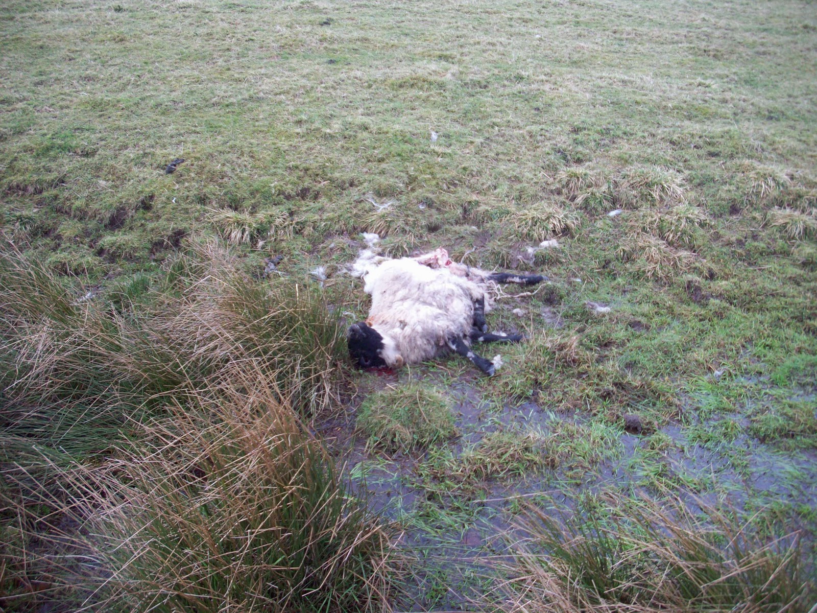
Parking up at the Errington Arms car park, I started by picking up litter before passing into the first field of the Trail. I had only been walking for a few minutes when I came upon a dead sheep. It was lying in the bottom of the waterlogged Vallum ditch.
Dead sheep.
I have reported this to Hadrian's Wall Heritage Limited, who will try and contact the farmer. Because of where it had fallen, I was unable to get its ear tag number which would enable the sheep to be identified to the flock it came from and its actual owner.
The first half of the Trail, although very wet and muddy was free of molehills. Stanley Plantation was also very wet and muddy, even where wood chippings have been spread. In one part of the path, water was running out from underneath the wall and collecting in a large puddle.
Water spreading out onto trail.
Coming to the B6381 road crossing, I found some areas of erosion and waterlogged areas.
Problem area.
Trail erosion.
After the road crossing the mole hills started and continued all the way to Heavenfield. The trail became very waterlogged and in some places the bottom of the Vallum is full of water and is spreading out onto the trail.
Water coming out of Vallum on left and spreading onto trail.
Over the whole of my walk, I picked up a small amount of litter, plastic bottles and glass bottles.
I met 8 walkers, 6 were completing the full trail and they were on day four of their walk. Two were day walkers completing a small part of the trail.
The recent wet weather is making the trail very wet and muddy. We will need a period of dry weather before the main season begins in May, to dry out the ground.
Certain areas will have to have a small amount of maintenance to prevent further erosion by the thousands of walkers who will arrive for the new season. We will have to monitor the problem areas and ensure the trail and archaeology are protected.
The snow of November and December 2010 has gone, to be replaced by very hard ground frosts. Over the last few days the temperatures have started to rise and with this in mind I decided to make a visit to the section. My aim was to see how the trail had stood up to the coldest winter in this area for a number of years.
National Trail - Looking East towards Portgate.
The Trail on grazing land was in good condition, it was fairly dry, the only problem encountered was dozens of molehills.
Molehills across the Trail.
The path through Stanley Plantation was very wet and muddy in places. This may be a problem when the season opens again in May. Some maintenance has been carried out since my last walk: wood chippings have been spread over the problem areas.
Stanley Plantation.
Generally speaking, the Trail is is good condition, despite the harshness of the winter weather we have experienced.